


T-Misery

JLKino
User
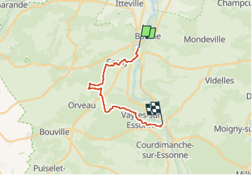

Length
15.2 km

Max alt
138 m

Uphill gradient
201 m
Km-Effort
17.9 km

Min alt
52 m

Downhill gradient
206 m
Boucle
No
Creation date :
2025-05-15 07:52:26.56
Updated on :
2025-05-15 13:05:12.865
5h12
Difficulty : Difficult

FREE GPS app for hiking
 SityTrail
IGN / Geographical institutes
SityTrail Plus
The world is yours!
About
Trail Walking of 15.2 km to be discovered at Ile-de-France, Essonne, La Ferté-Alais. This trail is proposed by JLKino.
Photos


Positioning
Country:
France
Region :
Ile-de-France
Department/Province :
Essonne
Municipality :
La Ferté-Alais
Location:
Unknown
Start:(Dec)
Start:(UTM)
452072 ; 5370391 (31U) N.
Comments